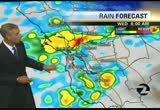
steve paulson will be here early tomorrow morning, beginning at 4:30, tracking the cold temperatures that start out near monday. high pressure is still in command of our weather. the dry weather pattern continues. it will be mild to warm for monday. this cooler air begins to sweep into the region. also a few extra high clouds. a major drop off in temperatures by wednesday. by wednesday, we will be tracking rain showers first thing for the morning commute. we could have patchy, dense fog develop, especially toward the central valley. even in some of the inland valleys once again. a few patches out there. partly, to mostly sunny for the afternoon hours. an increase in the cloud cover. no rainfall yet. by tuesday evening, the leading edge of the shower activity begins to push into the region, and spreading to the south first thing wednesday morning. also, a major drop off in temperatures, as that cold air moves into the region. still the possibility of a few scattered showers for wednesday afternoon. temperatures for tomorrow, mainly in the 60s. these numbers about the same as today, or
 Live Music Archive
 Librivox Free Audio
 Metropolitan Museum
 Cleveland Museum of Art
 Internet Arcade
 Console Living Room
 Books to Borrow
 Open Library
 TV News
 Understanding 9/11